/-84.955921,33.446100,12/300x186@2x?access_token=pk.eyJ1IjoibHpjYW11dGkiLCJhIjoiY2o3a281dWJvMHE4ajMzbGF4enJyNHRiciJ9.DhYjvPk5E_wJvys5DU5v2A)
The River as Border
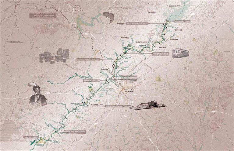
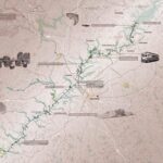
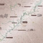
While shoals and fords along the River are historic points of confluence once used by Native Americans, the River has also been a dividing line throughout various historical moments within the region. As the pressure of white settlement increased in the 19th century, the River served as a border between native and whites lands. Construction of infrastructure like railroad trestles, essential in the growth of the region, was needed to span the River to connect to points north of Atlanta. Atlanta’s status as a rail hub made it a target during the Civil War, and the River again served as a barrier, embodied by the earthworks that line its banks in Cobb and Fulton counties. Ferries and railroad crossings gave way to the expansion of roads tailored to the automobile in the early 20th century. The Chattahoochee would later be the front for racial lines drawn during late 20th century.
Currently, given the uneven distribution of crossings and access points along the Chattahoochee, the River still represents a border for many communities. The Greenway Study is an opportunity to bring people back to the water’s edge and to reconnect communities across the iconic water body. Particular attention to equitable access along and across the River should be a priority throughout the study area. Moments where the greenway aligns with historic borders and boundaries should be recognized in the interpretive marking strategy that defines the corridor.