/-84.087945,34.139686,12/300x186@2x?access_token=pk.eyJ1IjoibHpjYW11dGkiLCJhIjoiY2o3a281dWJvMHE4ajMzbGF4enJyNHRiciJ9.DhYjvPk5E_wJvys5DU5v2A)
The River as Bounty
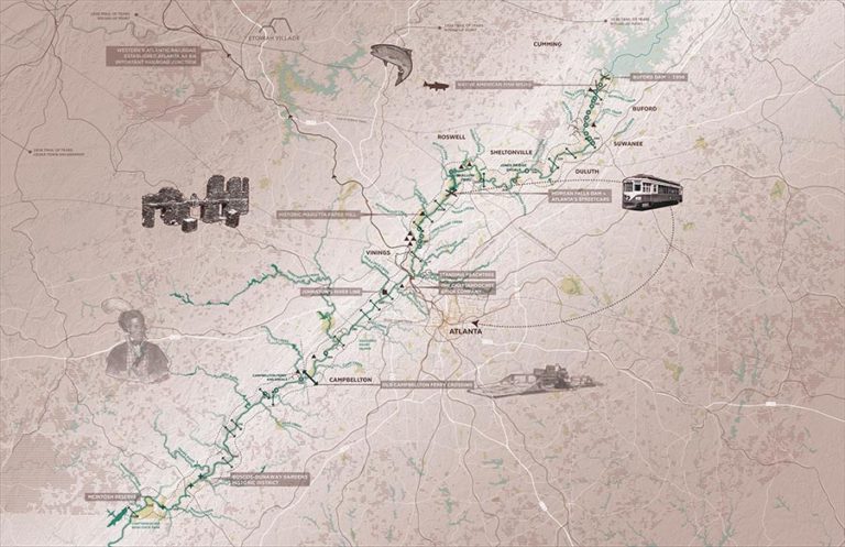
Throughout the history of humans’ interaction with the Chattahoochee River, the River has played dual roles as both a source of bounty and as a border. Fish weirs and prehistoric sites from the Woodland Period and later represent the bounty the River produced in the form of fertile, arable land and aquatic food sources. This bounty was later recognized in agriculture of historic period settlers with the production of cotton and other cash crops. The River and its creeks provided a means to power mills and was later harnessed to provide power to Atlanta’s growing streetcar system at Morgan Falls Dam. Early streetcars linked Atlanta with the River at Bolton and would bring city dwellers there for recreation. Goods, like cotton, were poled down the River along short distances, linking historic plantations to railroads.
Today, the River continues to sustain its surrounding population as a recreational retreat, an abundant fishery, and a critical piece of the Metro Atlanta Area water supply. The historic and contemporary relationships between the River, its resources, and the growth and development of the region is a critical narrative that should shape the design of the Greenway. The design should prioritize access or visibility to physical relics, such as mill ruins along the River or industrial sites of significance like the Chattahoochee Brick Company. Historic moments along the River corridor that lack physical remains, such as historic ferry crossings and significant prehistoric sites, should be represented with creative signage strategies. Natural and manmade landmarks in the River, such as shoals, bridges, and dams, should be prioritized as interpretive moments in the Greenway design. They represent overlapping historic narratives and weave together different time periods in the River’s past.